Live in Newport and have a preference on where to put new trails moving forwards? The city wants to hear from you. Now in the process of developing a Trail Network Plant to guide it in the future …
This item is available in full to subscribers.
To continue reading, you will need to either log in, using the login form, below, or purchase a new subscription.
If you are a current print subscriber, you can set up a free website account and connect your subscription to it by clicking here.
Otherwise, click here to view your options for subscribing.
Please log in to continue |
Live in Newport and have a preference on where to put new trails moving forwards?
The city wants to hear from you.
Now in the process of developing a Trail Network Plant to guide it in the future development of walking and bike trails, the City of Newport is currently seeking resident’s feedback as it seeks to create a place where all can better get around.
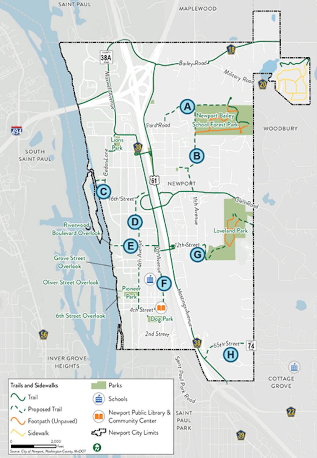
Listed in alphabetical fashion are eight proposed future trail routes along with their specific details, as follows:
A. Bailey School Forest / Ford Road
• Connects to existing trails in Bailey School Forest Road and along Hastings Avenue
• Connects to residential neighborhood east of Highway 61
B. Sterling Street / 11th Avenue
• Connects to Bailey School Forest Park & neighborhood park at 10th Avenue/17th Street
• Connects to existing trail on north side of Glen Road
C. Cedar Lane / 16th Street
• Connects to Mississippi River Overlook and Lions Park
• Serves large residential neighborhood
D. 4th Avenue
• Connects to Newport Elementary School, sports fields, and playground
• Serves large residential neighborhood
E. 12th Street
• Connects to 12th Street pedestrian bridge over Highway 61
• Connects to Riverwood Boulevard overlook and proposed trail along 4th Avenue
F. 7th Avenue / 4th Street / 5th Avenue
• Connects to Historic Public Library and Newport Dog Park
• Connects to 12th Street pedestrian bridge over Highway 61
G. 12th Street / Loveland Park
• Connects Loveland Park to existing trail along Hastings Avenue
• Connects to 12th Street pedestrian bridge over Highway 61
H. 65th Street / County Road 74
• Provides a safe walking/biking route to Oltman Middle School
• Fills a trail gap between Hasting Avenue and Geneva Avenue South
Residents can rank which they prefer in descending order, with ‘1’ being the most important and ‘8’ least important.
Following the ranked preference on proposed future trail routes are three questions, pertaining to special comments on the trail plan, other locations for potential future trails, and intersections that residents think are unsafe or find uncomfortable to cross the street and might be considered for future street crossing improvements.
The online survey on proposed future trail improvements is currently accessible via link at the city website at www.newportmn.gov. The survey closes Sunday, Oct. 27.